
Bridge Clock – Observator, Rotterdam, early 20th century
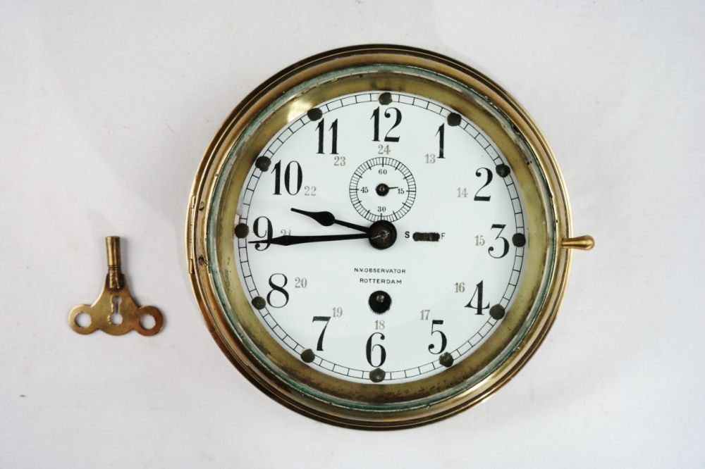
Very solid made brass ships clock of about 3 kilo! On the enamel dial 1-12 and an inner ring indicating 13-24 in Arabic numerals. Observator made ship clocks of a high standard. Catalog: MA.1-12 Date: 1920-1930 HD: 6,5×20,5 cm (2,6×8,1”) Signed: N.V.OBSERVATOR ROTTERDAM Origin: the Netherlands Condition: little chip on the glass and on the…
Read MoreWalking Stick with Monkey Fist, Spermwhale – Early 19th century
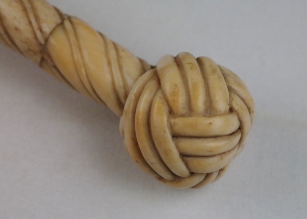
Beautiful sailor made walking stick with fine craftmanship made of spermwhale. Catalog: MA.1-10 Date: ca. 1820 L: 88 cm (34,6”) Signed: not signed Origin: England Condition: with almost invisible restoration
Read MoreTerrestrial and Celestial Table Globes – J. & W. Cary, London, 1816
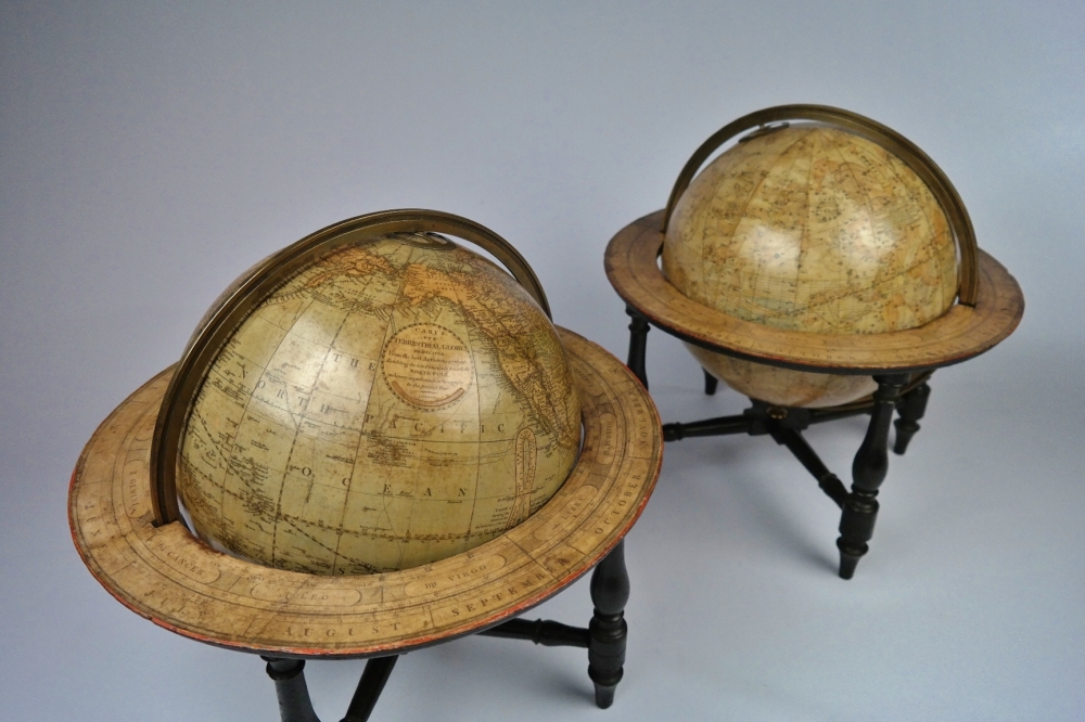
A gorgeous pair of globes, two centuries old, with brass meridian and wooden horizon, published by John and William Cary, known as the greatest globe makers of their era. The celestial globe dates 1816, the date of the terrestrial globe is hidden. The globes rest on ebonized stands, Regency period. In the globes there are…
Read MoreSymbols and Abbreviations Brittish Admiralty Chart 5011, published in 1954
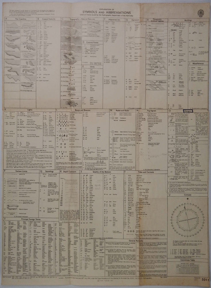
Authentic map of 1954 with small corrections untill 1964. Catalog: BK.1-12 Dimensions: 45×61 cm (17,8×24”) Condition: VG+, folded as issued
Read MoreMonserrat – Plymouth Anchorages, West Indies – British Admiralty Chart 254, published in 1869
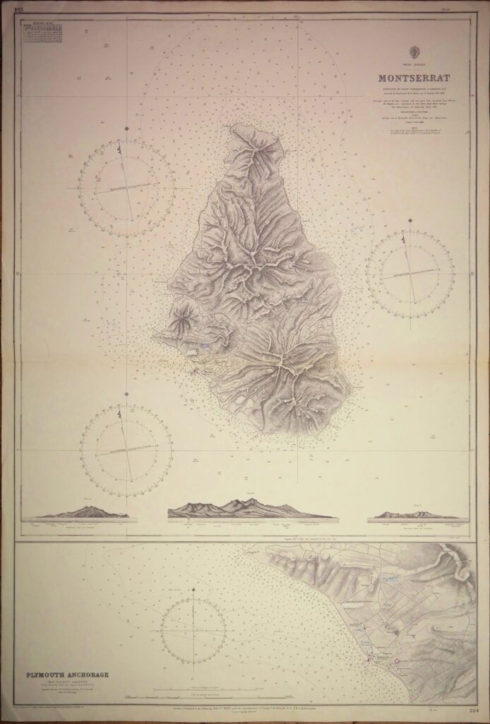
Impressive and very detailed sea chart with beautiful land views. Catalog: AC-254 Surveyed 1867 1rst publication: 1869 Edition: 1869 Dimensions: standard Condition: VG+ In our chart room are hundreds of Admiralty fathom charts from before WWII. All in good condition, many unused. Ask for the availability list.
Read MoreArquipélago de Cabo Verde – North Atlantic – British Admiralty Chart 366, published 1820
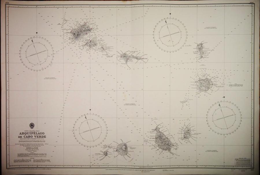
Very detailed and authentic chart with sailing directions, tidal information and so on. Catalog: AC-366 Surveyed from in 1819-1820 and compiled from Portuguese plans. 1rst Publication 1944 Edition 1944 Dimensions: standard Condition: VG+ In our chart room are hundreds of Admiralty fathom charts from before WWII. All in good condition, many unused. Ask for the…
Read MoreWest Indies – Marigot Harbour to Pointe du Cap – British Admiralty Chart 197, published in 1875
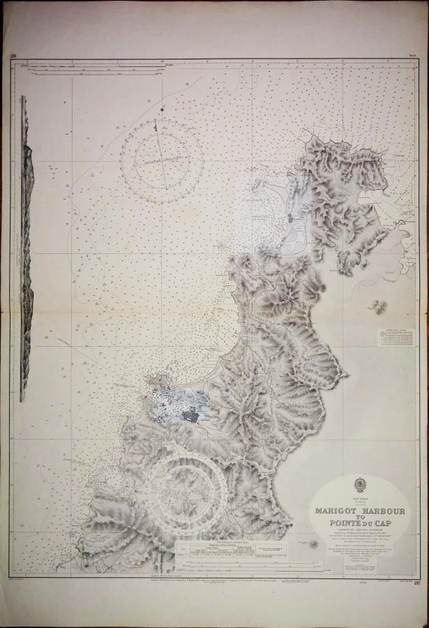
Very detailed chart with beautiful land views. Catalog: AC-197 Surveyed 1863 – 1887 1rst publication: 1875 Edition: 1915 Dimensions: standard Condition: VG In our chart room are hundreds of Admiralty fathom charts from before WWII. All in good condition, many unused. Ask for the availability list.
Read MoreIreland, East Coast – Skerries Islands to Lough Carlingford with Dundalk Bay – British Admiralty Chart no. 44, published in 1883
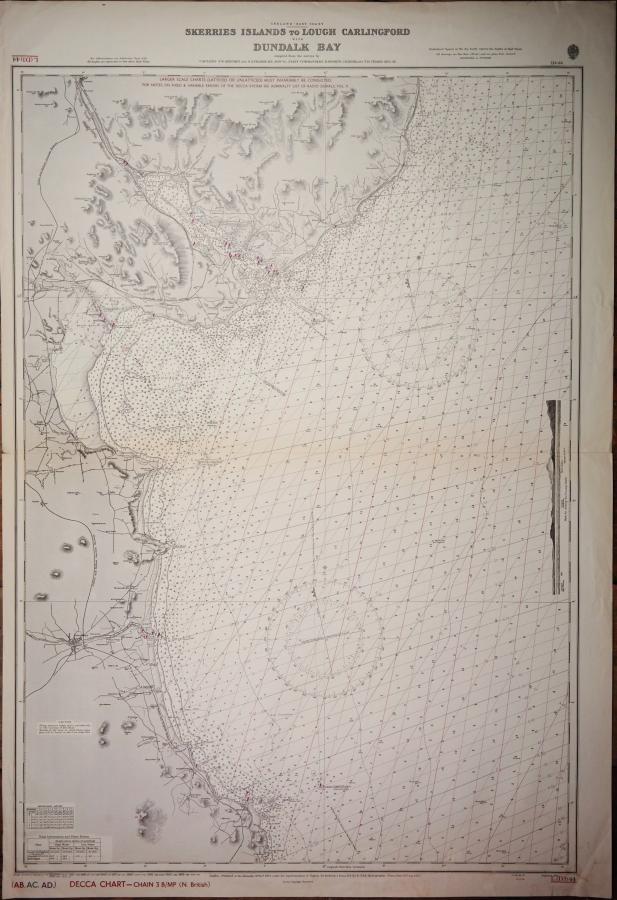
Authentic chart with land view, tidal information and so on. With decca patern. Catalog: AC-44 Surveyed from 1839 – 1881 1rst publication: 1839 Edition: 1839 Dimensions: standard Condition: VG+ In our chart room are hundreds of Admiralty fathom charts from before WWII. All in good condition, many unused. Ask for the availability list.
Read MoreSalomon, Chagos Archipelago – Indian Ocean – British Admiralty Chart no. 4, published in 1830
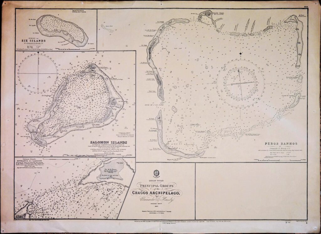
Authentic and detailed chart of the Principal Groups of the Chagos Archipelago with Salomon Islands. Catalog: AC-4 Surveyed from 1837 1rst publication: 1830 Edition: 1881 Dimensions: half format 71×52 cm (28×20,5 in) Condition: VG In our chart room are hundreds of Admiralty fathom charts from before WWII. All in good condition, many unused. Ask for…
Read More